


PROPERTY SEARCH


Joseph is the third large storm to hit Spain in as many weeks: This is where it will rain and how much
The weekly weather forecast from January 26 to 29 is for more heavy rain and emergency alerts

Another powerful storm, this one named Joseph by Portuguese meteorologists, will bring heavy rain to much of mainland Spain starting this Monday January 26, along with snow in mountainous areas, strong winds and rough seas on the coast. Joseph makes its arrival in Spain hot on the heels of Storm Ingrid, which continued to batter much of the north of the country over the course of this weekend.
While rainfall is expected to affect much of the country, the worst hit area will be in Galicia, specifically in Pontevedra on the Atlantic coast. On Monday and into the early hours of Tuesday 27, this area is subject to a red weather alert, the highest level of weather warning, for extreme danger. Rainfall could exceed 120 millilitres in 12 hours, and Aemet anticipates possible flooding and flash floods, urging everyone to take extreme precautions and follow the recommendations of Civil Protection.
Strangely enough, temperatures will actually be milder this week than last, with minimums around 8-12ºC inland and 14-17ºC in coastal areas exposed to the wind. However, Wednesday will be the exception due to a polar air mass that will bring minimum temperatures between 1 and 4ºC inland and some light frosts on the northern plateau and mountainous areas.
Maximum temperatures will also be mild on Monday and Tuesday, with values between 10 and 13ºC inland and up to 15-16ºC on the coast. On Wednesday, they will drop below 5ºC inland, before recovering again afterward. On Thursday and Friday, temperatures could exceed an amazing 20°C in the eastern and southern part of mainland Spain, according to meteorologists due to the ‘Foehn effect’ of westerly winds.
The Canary Islands, as is usual, will escape any of the rain, storms, wind and snow, instead enjoying stable temperatures in the mid-20s.
Monday January 26
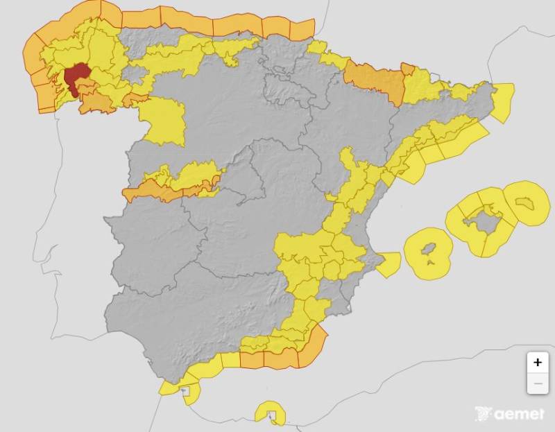
The week begins with widespread and heavy rainfall in the western third of mainland Spain and the centre, around Madrid. Accumulations of rain in excess of 50 millilitres in 24 hours are expected in western and southern Galicia, the Sierra de Gredos, Grazalema and the southeastern mountain ranges. In Cantabria, Castilla y León, Castilla-La Mancha, the Pyrenees and in central Andalucía, rainfall will range between 10 and 25 millilitres in 24 hours.
Tuesday January 27
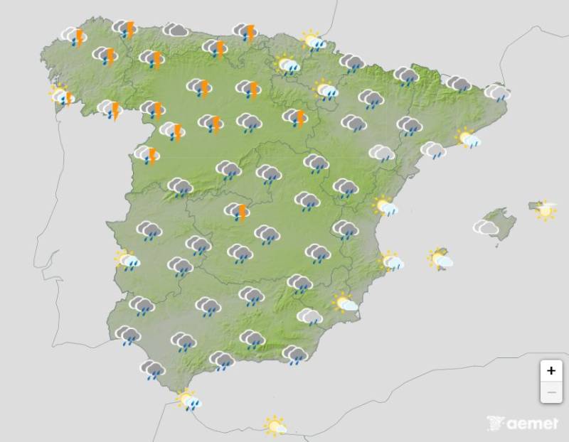
Tuesday will again be very rainy, with between 15 and 30 millilitres of rainfall forecast in 24 hours across pretty much all of Spain, with the exception of the northeastern inland areas and on the eastern Mediterranean coast. Strong thunder and lightning storms are also forecast throughout the whole afternoon.
However, it is actually for strong winds that most of the country is labouring under a weather alert for, with warnings of gusts reaching up to 70kmh in affected areas, namely the Balearic Islands and much of mainland Spain, excluding the northeastern corner up near Barcelona.
Wednesday January 28
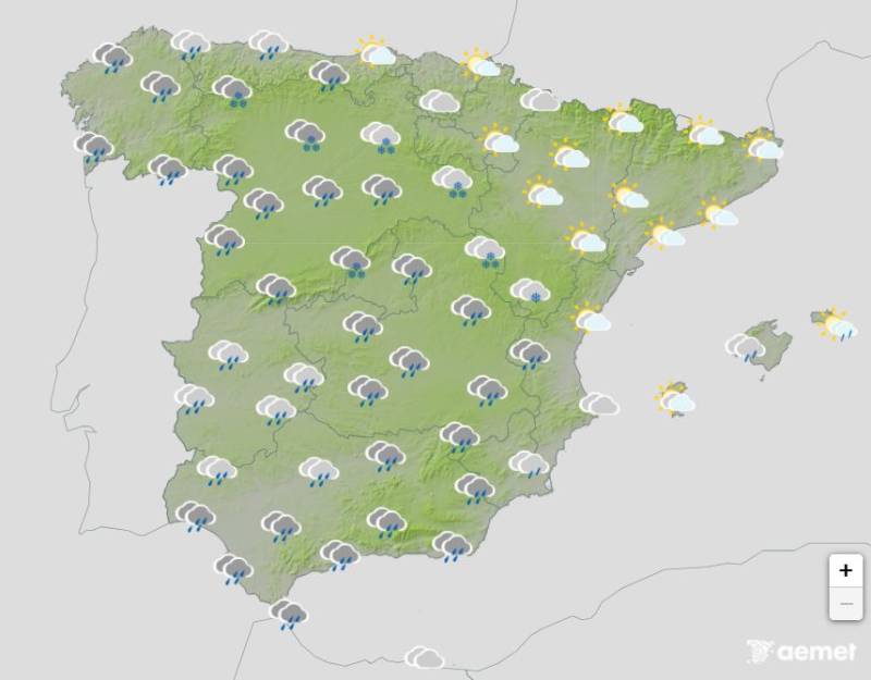
On Wednesday, the heavy rainfall continues, with areas such as Galicia, Extremadura and the Sierra Nevada, Sierra de Cazorla and Sierra Segura mountain ranges in Andalucía expecting to see in excess of a frightening 100 millilitres.
The snow level will plummet late on Tuesday and going into Wednesday, meaning that snow is forecast across every single mountain range and high-altitude area in mainland Spain.
Thursday January 29
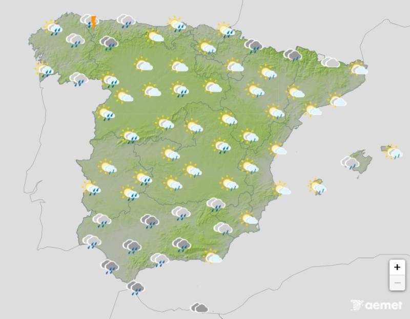
By Thursday afternoon, it will be a bit brighter and sunnier, especially across the northeast and centre of Spain, but there will still be plenty of rain – between 10 and 40 millilitres in Galicia, Cantabria, the Pyrenees, southern Castilla-La Mancha and northern Andalucía. Rain will be more scattered along the coast of Catalonia, Alicante, the Region of Murcia and in Almería.
Looking ahead to Friday and Saturday, new weather fronts associated with the low-pressure system will bring heavy rainfall to the western half of the country, especially in Galicia, northern Extremadura, the Cantabrian coast and parts of western Andalucía.
For more weather news go to our Weather & Climate page or follow the Spain Weather Watch Facebook group for regular updates
Image 1: fotokon
Images 2-5: Aemet


Sign up for the Spanish News Today Editors Roundup Weekly Bulletin and get an email with all the week’s news straight to your inbox
Special offer: Subscribe now for 25% off (36.95 euros for 48 Bulletins)
OR
you can sign up to our FREE weekly roundup!
Read some of our recent bulletins:
Discount Special Offer subscription:
36.95€ for 48 Editor’s Weekly News Roundup bulletins!
Please CLICK THE BUTTON to subscribe.
(List price 3 months 12 Bulletins)
Read more stories from around Spain: